


Shapefile over Map (Demo)
Deskripsi Shapefile over Map (Demo)
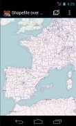
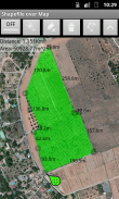
Load your own shapefiles with this Geographic Information System (GIS) directly from the sdcard of your mobile device and visualize them over a map. You can also edit the values of its dbf table and use it in offline mode, loading maps from your memory card.
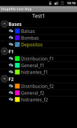
With this GIS application, you can select and load a shp file or load an entire folder automatically.
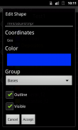
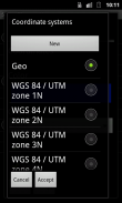
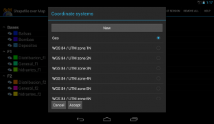
You can select one of these shp files and mark it as the active layer and if you do a long press over one of them you can change its coordinate system, its color or make it invisible.
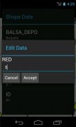
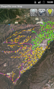
The map will display a series of icons, belonging to each of the records in the active layer, which when pressed will allow you to view and edit information from its corresponding attribute table.
The application also allows you to view your current position via GPS and center the map on it.
You can choose between several online map servers.
This is a demo version, some functionalities are only available in the full version.
Memuat shapefile Anda sendiri dengan Sistem ini Informasi Geografis (GIS) langsung dari sdcard dari perangkat mobile Anda dan memvisualisasikan mereka atas peta. Anda juga dapat mengedit nilai dari tabel DBF dan menggunakannya dalam modus offline, memuat peta dari kartu memori Anda.
Dengan aplikasi GIS ini, Anda dapat memilih dan memuat file shp atau memuat seluruh folder secara otomatis.
Anda dapat memilih salah satu file shp ini dan menandainya sebagai lapisan aktif dan jika Anda melakukan tekan lama lebih dari satu dari mereka Anda dapat mengubah sistem koordinatnya, warna atau membuatnya tidak terlihat.
Peta akan menampilkan serangkaian ikon, milik masing-masing catatan di lapisan aktif, yang bila ditekan akan memungkinkan Anda untuk melihat dan mengedit informasi dari tabel atribut yang sesuai.
Aplikasi ini juga memungkinkan Anda untuk melihat posisi Anda saat ini melalui GPS dan peta di atasnya.
Anda dapat memilih antara beberapa server peta online.
Ini adalah versi demo, beberapa fungsi hanya tersedia dalam versi lengkap.
Load your own shapefiles with this Geographic Information System (GIS) directly from the sdcard of your mobile device and visualize them over a map. You can also edit the values of its dbf table and use it in offline mode, loading maps from your memory card.
With this GIS application, you can select and load a shp file or load an entire folder automatically.
You can select one of these shp files and mark it as the active layer and if you do a long press over one of them you can change its coordinate system, its color or make it invisible.
The map will display a series of icons, belonging to each of the records in the active layer, which when pressed will allow you to view and edit information from its corresponding attribute table.
The application also allows you to view your current position via GPS and center the map on it.
You can choose between several online map servers.
This is a demo version, some functionalities are only available in the full version.
Shapefile over Map (Demo) - Versi 3.1
(28-03-2018)Shapefile over Map (Demo) - Informasi APK
Versi APK: 3.1Paket: com.dabebro.somdemoVersi Terakhir dari Shapefile over Map (Demo)


Aplikasi pada kategori yang sama


Anda juga mungkin suka...

Aplikasi pada kategori yang sama


